The Papua Blog
Papua, West Papua, PNG...
A brief explanation of the terminologies
Words and photos by Marc Weiglein
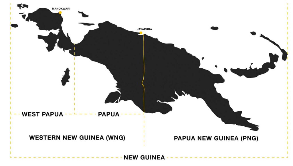
The island of New Guinea is the second largest island in the world after Greenland. A border runs through the centre of the island, as if drawn with a ruler. There is quite a bit of confusion about the correct naming of the various “parts” of New Guinea.
WESTERN NEW GUINEA & PAPUA NEW GUINEA
The eastern part of the island has been part of the independent state of Papua New Guinea (PNG) since 1975. The western part, called Western New Guinea, became part of the Republic of Indonesia in 1963. In 2003, Western New Guinea was administratively divided into the two distinct provinces of Papua and West Papua.
WEST PAPUA & PAPUA
Unfortunately, the whole of Western New Guinea is often called West Papua. However, since the subdivision this name has been misleading, as the name West Papua now only designates the westernmost part of Western New Guinea. That includes the Vogelkop Peninsula and the offshore islands, including the Raja Ampat archipelago. The much larger part of Western New Guinea is called Papua. Popular destinations located in Papua include the Baliem Valley, the Mamberamo Basin, the territory of the Asmat, the territory of the Korowai, and the Carstensz Pyramid. The province of Papua covers an area of 320,000 km2 (123,180.51 sq mi) whereas the province of West Papua covers an area of 140,000 km2 (54,199.33 sq mi).
The capital of the province of Papua is Jayapura, the capital of the province of West Papua is Manokwari.
The articles in this blog deal exclusively with the Indonesian western half of the island of New Guinea, and the main focus is on Papua.
Not quite clear? This map of New Guinea hopefully helps with the last problems of understanding.


